Prof. Anthony B. Watts
Professor of Marine Geology and Geophysics
Sedimentary basins
Sedimentary basins are regions of the Earth's crust dominated by subsidence. The subsidence provides the depocentre for sediments such as sandstones, mudrocks, and limestones to accumulate, in some cases to a thickness >10 km. Each continent has sedimentary basins, including Antarctica. The deepest basins (>15 km) are found in the southern Caspian Sea and in the western Gulf of Mexico. Sedimentary rocks are important because they are the "tape recorder" of past climate, sea-level and environmental change. They are also the world's largest repositories of oil and gas.
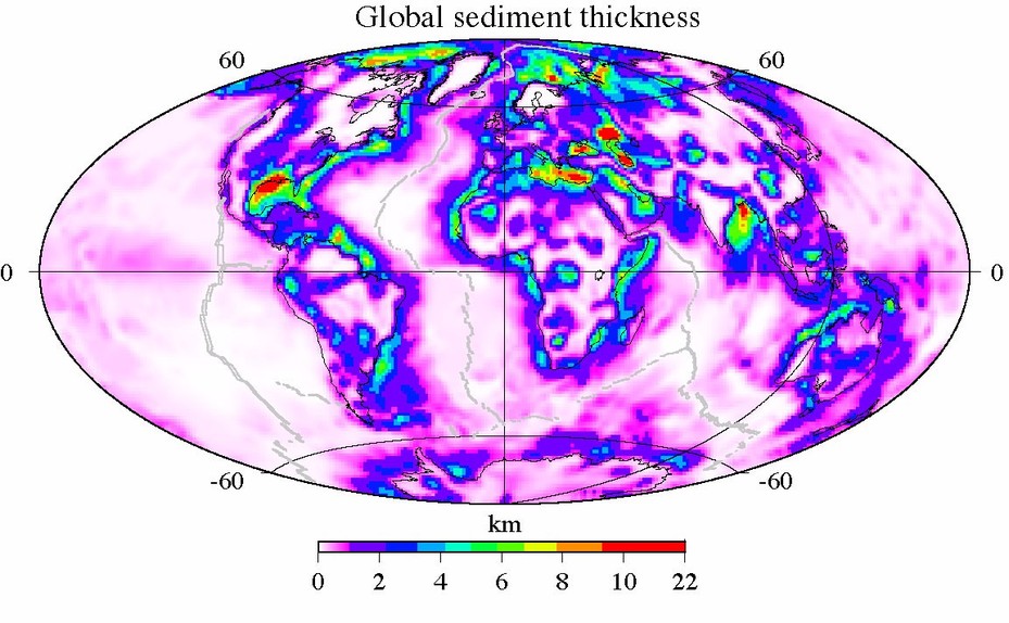
Global sediment thickness based on the 1o x 1o compilation of Laske and Masters (1997).
We may divide sedimentary basins into three main types, depending on their plate tectonic setting. Rift-type basins form at extensional plate boundaries, for example, at continental margins. Foreland-type basins form at compressional plate boundaries in front of migrating fold and thrust belts. The third type of basin forms in strike-slip fault settings.
It is now generally recognised that the main basin forming mechanism issediment loading. The displacement of water by terrigenous clastic rocks (e.g. sandstones, mudrocks, conglomerates + breccias), for example, represent a load on the surface of the crust which will bend or flex downwards under their weight. Biochemical organic deposits (e.g. limestones and dolomites) will have a similar effect, as will chemical precipitates (e.g. evaporites) and volcaniclastic (e.g. tuffs) deposits. The thickness of sediment that can accumulate due to loading depends on density, but it is approximately 2.5 times the water depth that is available. Therefore, if a 6 km deep water basin (e.g. the present-day Phillipine Sea basin) is rapidly infilled by sediment then the total thickness of sediment that could accumulate would be 2.5 x 6.0 = 15 km. Such a model implies a single shallowing upward sequence such that the early sediments would be deposited in deep-water while the later sediments would be deposited in shallow-water.
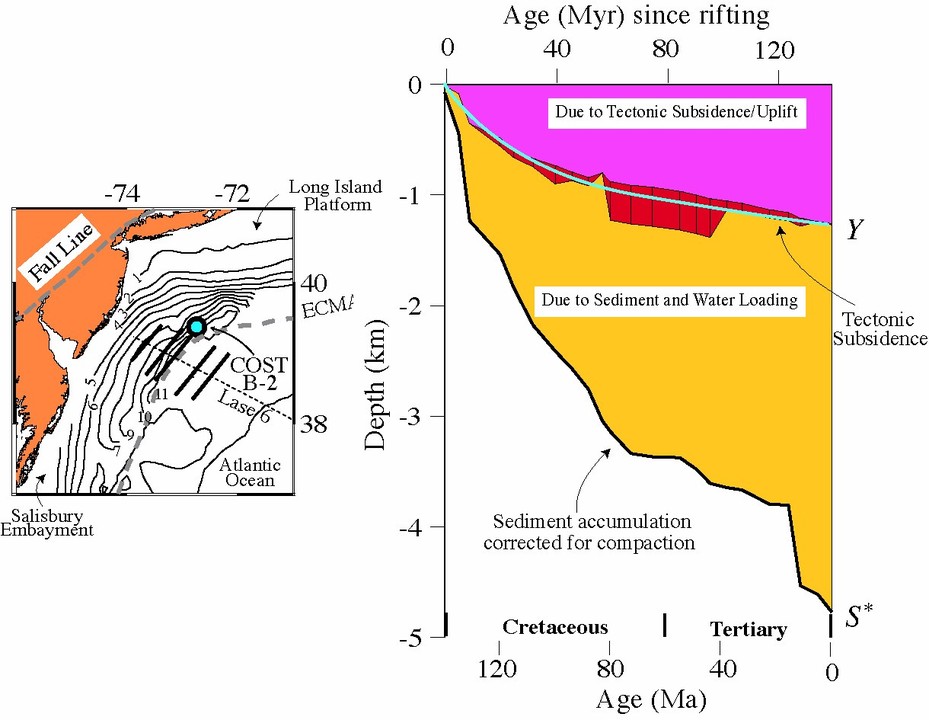
Tectonic subsidence obtained from backstripping biostratigraphic data at the COST B-2 well, offshore New Jersey, USA. Based on Steckler and Watts (1978).
The sediments in deep basins accumulate, however, in a range of depositional settings, including alternating shallow-water and deep-water environments. This observation suggests that factors other than sediment loading are responsible for basin formation. A useful technique to isolate these other factors isbackstripping. Backstripping uses biostratigraphic, porosity Vs. depth, and paleoenvironment data in deep wells to correct the stratigraphic record for the effects of sediment and water loading and obtain the depth that "basement" would be in the absence of these loads. We refer to this depth as the tectonic subsidence and uplift.
The different types of sedimentary basins have varying tectonic subsidence and uplift curves. Rift-type basins tend to have concave-up curve with the subsidence fast early on after rifting and then slow later on. Foreland basins, in contrast, have concave-down curve with the subsidence slowest early on and then fastest later on. Strike-slip basins generally subside rapidly and their backstrip curves show features of both rift-type and foreland-type basins. By comparing the backstrip curves to geophysical models we have learnt a great deal about the various factors responsible for basin formation.
McKenzie (1978), for example, attributed the tectonic subsidence and uplift ofrift-type basins to heating and thinning of the crust and mantle at the time rifting. The crustal thinning causes a rapid initial subsidence while the thinning of the mantle causes a slower thermal subsidence. The McKenzie model of rifting and its variants that take into account finite duration rifting, lateral heat flow(Cochran, 1981) and depth-dependant extension (Wernicke, 1985) explain the backstrip curves of many rift-type basins. The main discrepencies are in basins associated with magmatic underplating (e.g. Hatton-Rockall) where the subsidence is less than expected and in basins characterised by orogenic loading (e.g. West Taiwan), rotation on tilted fault blocks (e.g. Valencia Trough), or salt collapse (e.g. northern Gulf of Mexico margin) where the subsidence is more.
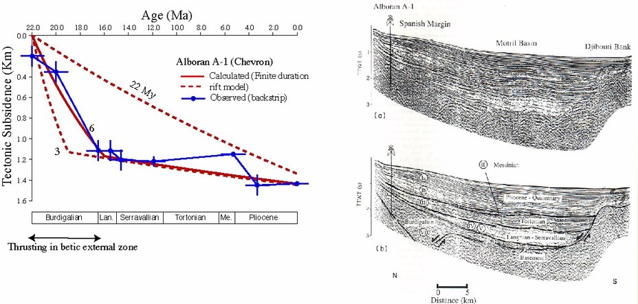
Comparison of the backstripped tectonic subsidence at the Alboran A-1 well offshore Andalucia (Spain) to calculations based on a stretching model with finite duration rifting. The best fit between observed and calculated is for stretching by a factor of 1.2, rift initiation at 24 Ma, and a 6 Myr duration of rifting. Rifting occurred during the Burdigalian and coincides with thrusting in the Betic external zone and growth on extensional normal faults in the Motril basin. Based on Watts et al. (1993).
In contrast to rift-type basins, foreland-type basins are characterised by a slow subsidence early on and a rapid subsidence later on. This has been attributed by Price (1973), among others, to the approach at a locality of a thrust and fold load. When a thrust and fold load is in the far-field there is little subsidence, but as the load moves towards the locality, flexure causes first a slight uplift as it 'rides the flexural bulge' followed by an increasingly large subsidence. The load and flexure is reflected in the Bouguer gravity anomaly. Mountain belts which are associated with a gravity low (e.g. Andes, Himalaya) are dominated by surface (i.e. topographic loads) while mountains with a high-low gravity "couple" (e.g. Appalachian, Oman) are associated with surface as well as sub-surface loads. Examples of sub-surface loads include obducted ophiolite bodies, intra-crustal thrusting, and dense downgoing slabs.
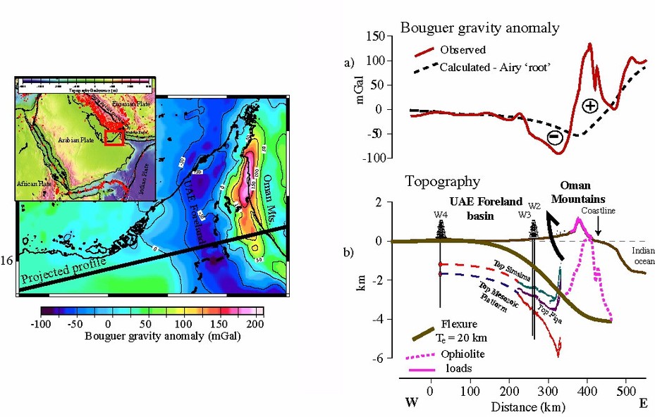
Comparison of the observed and calculated flexure in the United Arab Emirates (UAE) foreland basin. The basin formed by orogenic loading of a Tethyan rifted continental margin. The Bouguer gravity anomaly couple of a high over the Oman mountains and a low over the UAE foreland basin suggest the loads comprise of both surface (i.e. topographic) and sub-surface loads. The most likely source of the sub-surface loads are ophiolites which were obducted onto the margin during the late Cretaceous. Based on Ali and Watts (2009).
Results from backstripping suggest that there are two main controls on the stratigraphic "architecture" of sedimentary basins: sediment loading and eitherthermal contraction and uplift (e.g. in rift-type basins) or orogenic loading(e.g. in foreland basins). Other factors such as compaction, paleoenvironment, and sea-level change all contribute but they are generally considered as secondary to the main controls.
Sediment loading is also a major control in strike-slip type basins. These basins are associated with much greater rates of tectonic subsidence than rift-type or foreland-type basins. They are found in transform margin settings (e.g. Ivory Coast) where differential subsidence forms a ridge and "back-basin" on the continent side and a trough on the ocean side and in fracture zone settings (e.g. Vema) where it forms a ridge and "back-basin" on the young oceanic crust side and a trough on the old oceanic crust side. The deepest strike-slip basins, however, are the pull-apart basins that form between overlapping strike-slip faults. Examples include the Vienna (Wagreich and Schmid, 2002) and Los Angeles (Rumelhart and Ingersoll, 1997) basins where there is evidence from backstripped curves of both transtension and transcompression (i.e. a dip-slip and thrust component to the strike-slip motion). Pull-apart basins probably form by ductile flow in the lower crust which compensates for extensional thinning and compressional warping in the brittle upper crust
In the early 80s several attempts were made to construct forward models of the stratigraphy of sedimentary basins. The first models were based on a combination of the main controls with relatively simple models for the sediment input. For example, the steer's head and clinoform break models considered sediment loading and thermal contraction in combination with sedimentaggradation (i.e. models in which successive sediment accumulations are vertical) and progradation (i.e. models in which successive sediment accumulations migrate horizontally) respectively. The significance of such models is that they showed how tectonics in the form of flexure and thermal contraction and uplift could account for not only the overall basin "architecture", but also some of the details of their internal stratigraphy such as the patterns ofonlap and offlap
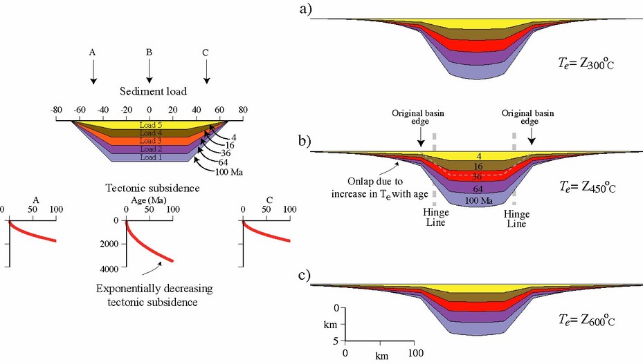
The Steer's Head model of sedimentary basin evolution. The model assumes that the tectonic subsidence of a basin increases exponentially with time and that they load a lithosphere that increases its flexural rigidity with time. Based on Watts et al. (1992).
Subsequent models considered more realistic schemes for the sediment input. Watts and Thorne (1984), for example, assumed that there was a sufficient supply of sediment to a rift-type basins in passive margin settings for them to build up to a constant "paleobathymetry surface". Sinclair et al (1991), however, assumed that the supply of sediment was diffusive such that there is a relationship between a topographic surface and the transport velocity from an eroded region in the fold and thrust belt to the flanking foreland basin.
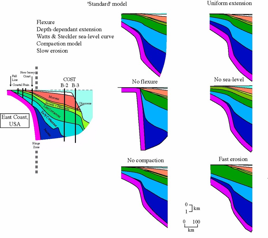
Comparison of observed and calculated stratigraphy of the East Coast, USA margin. The calculated stratigraphy has been computed assuming lithospheric flexure, depth-dependant extension, a smooth sea-level curve, a porosity Vs. depth that varies laterally across the margin, and slow erosion. The figure shows 5 cases where there is no flexure, no compaction, uniform extension, no sea-level, and fast erosion. Based on Watts and Thorne (1984).

Calculated stratigraphy of a foreland basin that forms by flexure in front of a migrating thrust load. The panels show the calculated stratigraphy for different assumptions on the slope angle, the elastic thickness, the thrust/fold load advance rate, and diffusion "subduing" coefficient. Based on Sinclair et al. (1991)
Basin modelling has advanced significantly since these early "geometrical" models for sediemnt accumulation. Today, there are a wide range of forward models available to build the stratigraphy of sedimentary basins. The advantage of such models is that they incorporate the primary controls on basin subsidence, such as sediment loading, as well as increasingly sophisticated methods of incorporating the sediment dynamics. The SEDPAK (Strobel et al, 1989) and SEDFLUX (Syvitski and Hutton, 2001) models, for example, are typical and include a provision to model both clastic and carbonate margins by taking into account the effect of slope instabilities, winnowing, and debris flows/turbidity currents on clastic sediment accumulation and the water-depth dependance of carbonate production

Forward model (SEDPAK) for the stratigraphy of a basin margin. The clastic input volume (i.e. the depositional distance and thickness), sea-level change, and tectonic subsidence are all specified as a function of time. The colours show the average porosity. The wedge comprises 4 main stratigraphic sequences, each of which is characterised by patterns of offlap and onlap. The offlap and onlap reflect a sea-level fall and rise respectively. From Strobel et al. (1989).
While forward models have successfully predicted the facies and stratal geometries of a sedimentary basin through time, they have their weaknesses. They require, for example, that a user specifies a large number of input parameters. Moreover, many of the models do not honor the observations very well.
Recently, there has therefore been increasing interest in using inverse rather than forward modelling techniques. These techniques have the potential to determine information about basin forming mechanisms directly from the observed stratigraphy. Two complimentary methods are strain rate inversion(Bellingham and White, 2002) and Process-Oriented Gravity Modelling(POGM) (e.g. Stewart et al., 2003). Strain rate inversion takes the backstrip data at, say, a well and inverts it to obtain the vertical strain rate history. It is a useful technique that enables both the number and duration of individual rifting events in a basin to be quantified. POGM uses a profile or grid of sediment thickness data to restore the crustal structure at the time of rifting and determine the sediment loads and their compensation. By comparing the calculated gravity anomaly due to rifting and sedimentation to observations, constraints can be placed on both the elastic thickness of the lithosphere and the relative role that rifting and sediment loading play in determining the crustal structure of a rift-type basin, compared to that of other processes such asmagmatic underplating, which thickens the crust, and extreme extension and mantle serpentinization, which thins it.
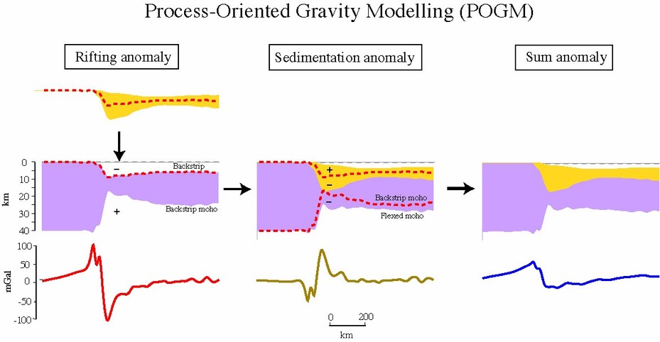
Process-oriented gravity modelling. Upper panels shows the rifting, sediment loaded, and final crustal structure. Lower panels show the rifting, sedimentation, and sum gravity anomaly. By comparing the calculated crustal structure and sum gravity anomaly to observations, constraints can be placed on the relative role of rifting and sediment loading in a rift-type basin.
Selected references
Ali, M. Y., and A. B. Watts (2009), Subsidence history, gravity anomalies and flexure of the United Arab Emirates (UAE) foreland basin, Geoarabia, In press.
Bellingham, P., and N. White (2002), A two-dimensional inverse model for extensional sedimentary basins, 2, Application, J. Geophys. Res., 107, 2260, doi:2210.1029/2001JB000174.
Cochran, J. R. (1981), Simple models of diffuse extension and the pre-seafloor spreading development of the continental margin of the northwestern Gulf of Alden, Proceedings of the 26th International Congress Symposium on Continental Margins, Oceanologica Acta, 154-165.
Laske, G., and G. Masters (1997), A global digital map of sediment thickness, EOS Trans. AGU, 78, F483.
McKenzie, D. P. (1978), Some remarks on the development of sedimentary basins, Earth Planet. Sci. Lett., 40, 25-32.
Price, R. A. (1973), Large-scale gravitational flow of supracrustal rocks, southern Canadian Rockies, in Gravity and tectonics, edited by K. A. DeJong and R. Scholten, pp. 491-501, Wiley-Interscience, New York.
Rumelhart, P. E., and R. V. Ingersoll (1997), Provenance of the upper Miocene Modelo Formation and subsidence analysis of the Los Angeles basin, southern California: Implications for paleotectonic and paleogeographic reconstructions, Geol. Soc. Am. Bull., 109, 885-899.
Sinclair, H. D., B. J. Coakley, P. A. Allen, and A. B. Watts (1991), Simulation of foreland basin stratigraphy using a diffusion model of mountain belt uplift and erosion : an example from the central Alps, Switzerland, Tectonics, 10, 599-620.
Stewart, J., A. B. Watts, and J. Bagguley (2000), Three-dimensional subsidence analysis and gravity modelling of the continental margin offshore Namibia, Geophys. J. Int., 141, 724-746.
Strobel, J., R. Cannon, C. G. S. C. Kendall, G. Biswas, and J. Bezdek (1989), Interactive (SEDPAK) simulation of clastic and carbonate sediments in shelf to basin settings, Computers & Geosciences, 15, 1279-1290.
Syvitski, J. P. M., and E. W. H. Hutton (2001), 2D SEDFLUX 1.0C: an advanced process-response numerical model for the fill of marine sedimentary basins, Computers & Geosciences, 27, 731-753.
Wagreich, M., and H. P. Schmid (2002), Backstripping dip-slip fault histories: apparent slip rates for the Miocene of the Vienna basin, Terra Nova, 14, 163-168.
Wernicke, B. (1985), Uniform sense normal simple shear of the continental lithosphere, Can. J. Earth Sci., 22, 108-125.
Collaborators: Evgenii Burov, Christine Peirce, Mohammed Ali, Andrew Lin